Packing for the field

As it turns out, you can’t just get down to McMurdo and immediately head out into the field to sample. Each science team has to pack and prep their own camps and go through several days of training in order to be cleared to go out into the field. Training includes: Field Safety (e.g. hypothermia prevention and risk management), Environmental Preparation (aka don’t contaminate Antarctica), and Fire Safety (aka don’t burn down your tent).

Here we are learning how not to burn down a tent with a camp stove:

2015-11-07 14.56.15

After all that training, we finally got to start packing….weighing and tagging everything that needs to be packed into helicopters to go out into the field:

2015-11-08 07.52.19

2015-11-08 07.52.35

Sarahs on the flight south

After getting fully outfitted, Team Sarahs had one last night in the New Zealand spring before heading south, then a 4:30am wakeup call for a 6 am check in at the USAP air terminal.

2015-11-06 05.27.29

The flights down to “The Ice” are made by either the Air Force (McChord) on a C-17 or the Air National Guard (Schenectady) on a C-130. Today we got to fly on the C-17, which you would think would be very roomy, but passengers are always squeezed in between the cargo, so its quite an adventure!

2015-11-06 06.01.57 2015-11-06 07.07.47 2015-11-06 07.09.16 2015-11-06 07.09.30 2015-11-06 07.09.51

After 5 hours on the plane, we arrived!

2015-11-06 13.35.54

2015-11-06 13.36.352015-11-07 07.53.28

24 hour sampling? Yes we did!

Our most epic sampling adventure yet began at 10am on August 24th. Usually, we sample the Athabasca Glacier every morning at about 10am. Keeping a consistent time allows us to accurately compare outflow and chemistry day-to-day and be sure what we observe are seasonal changes, not simply artifacts of a different sampling time. It seems logical, on a surficial level, that as daily temperatures get colder less of the glacier will melt, and subsequently the outflow will contain less water. If one day we measured outflow at 7am, then the next day at 3pm, the larger volume we measure could be due to time of day, or to day of year. As scientists, the goal is to definitively say why things happen, so we keep measuring at a consistent time.

IMG_4026

IMG_3215 copy

That said, there’s naturally some curiosity as to what happens during the other parts of the day! To answer that question, we devised a relatively simply sounding, yet path-through-Dante’s-inferno feeling, experiment: we would take measurements and samples every two hours for a 24-hour period. We tackled this from 10 am August 24th through 10 am August 25th, collecting water samples for preservation and chemical analysis ever 2 hours, in addition to collecting meltwater discharge measurements.

Every two hours, all three of us would hike up the hill to the melt channels. One person would collect 12 litres of water, carry it back to our “lab” in the van, filter and preserve it. One person would put on waders and measure the discharge across the melt channel. The third person would hold the safety rope of the person in the stream. Each 2-hour period, there was about a 5-15 minute break for everyone but the chemistry person, then it was back up the hill to rotate positions and do it all again. 

It was exhausting, tedious, COLD, and ended with field notes that read: “Midnight. Rather dark. No clouds, see stars. Water looks black. Everything looks black. Cannot see glacier. Water level down. No breeze to speak of. Coffee = mandatory.” FYI – the second one down is a night time “selfie.” Doesn’t it look great?

IMG_3255 copy IMG_3263 copy IMG_3266 copy IMG_3271 copy

But we were successful! We have 13 samples: 10am to 10am, all three of us survived!

IMG_3282 copy IMG_3288 copy

There were some rough patches: I want nothing more than sleep from 2-4am, Emily wants nothing more than sleep as soon as the sun comes up, and Anna prefers to avoid chemistry when things get stressful but we made it! Now there’s one more 24 hour sampling adventure to come in October. Check back to see how that goes!

Greetings and bonjour from the Canadian Rockies!

Hi Everyone! This is Emily, Mark, and Anna reporting in on our northern adventures to give you an idea of what we’ve been researching the past couple weeks and why we’re so excited to continue exploring in our natural laboratory.

This is just the beginning of a three-month field expedition to characterize subglacial weathering and seasonal progression at the Athabasca and Saskatchewan Glaciers, located in the Columbia Icefield. The Columbia Icefield has the largest accumulations of snow and ice south of the Arctic Circle and its meltwater runoff reaches the Arctic, Pacific, and the Atlantic Oceans. Based off of climate trends, a significant decline in alpine glaciers is predicted in the next 20 years; so, this meltwater may have both significant and wide-ranging effects on downstream ecosystems and human infrastructure. For example, salmon communities could be greatly disrupted if we see an increase in sediment production due to glacial erosion because of an increase in glacial melt. It could become more difficult for them to find food as the sediment builds up on the bottom of the outflow channels.

Tracking changes in the chemistry of glacial meltwater gives us clues to what’s happening below the glacier. This is important because what remains hidden to eye is an expansive series of subglacial meltwater channels that expand and evolve as temperatures rise and the meltseason progresses. We monitor the changes in the chemical composition to try to understand how fast the changes are occurring and to what scale. These measurements open up large windows into a hidden world beneath the ice.

The Athabasca Glacier has been the site of extensive GIGL field expeditions during May and July of 2011 and May of 2013. So, what we’re really interested in this year is the end of the meltseason to track what happens as the subglacial channels refreeze and close. It’s difficult to capture a full meltseason because conditions get really harsh during the final months. Just last September, a huge blizzard swept across the region! While it’s completely unknown what’s in store for us and when the meltchannels begin to refreeze, we’ve packed bundles of thermals, stocked up on thermos for warm soups, and are ready for whatever challenges the weather and glaciers will throw at us this season.

Each day, we’ve been taking a multitude of different samples to characterize different components of meltwater chemistry. From microbial communities and dissolved sediment load to total discharge measurements, we’re collecting samples as part of a huge collaborative project at the UM. Check out the pictures below to see what a typical day entails! We’ll also be traversing the icefield to collect ice samples and are working with a cool, new organization called Vicarious Earth to develop a sampling method for deep glacial moulins.

2014-08-14 14.06.55

In-situ measurements (water temperature, pH, etc) of surface melt with crampons for safety

Here’s Emily using the ADV to measure meltwater discharge and velocity. The water’s generally about a balmy 0.1°C (not quite freezing!) so we pass time by playing word games and attempting to answer life’s important questions like “Is there anything Mark won’t put peanut butter on?”

2014-08-11 15.38.37

Last Friday, we scouted out the Sakatchewan Glacier. After last year’s battles with glacial mud (Sakatchewan- 1 , Anna’s left boot- 0) and kilometers of snowshoeing/trekking over moraines and avalanche piles, we were prepared for a long and difficult day. But, we were surprised with how much things changed in what would have been a few months. It was an incredible hike through spruces and wildflowers like Indian paintbrush and alpine lupin. Each turn had us amazed with how lucky we are to be out here for the next couple months. The difference in the sampling site was remarkable as well. The summer melt caused the lake in front of the glacier to become quite expansive. We’ve scouted out a good route and hopefully,we’ll be able to get even closer to the toe next time!

May 2013

May 2013

August 2014

August 2014

We’ve been having a really, really, really great time exploring the Rockies in our time-off. Here we are in a river-eroded formation, but you can also see how the rock has been uplifted and rotated from when mountain-building activity, hundreds of thousands of years ago, created what we’ve come to know and love as the Canadian Rockies. More adventures tomorrow when we set sail down the Athabasca River in our tiny rowboat after we finish our morning sampling! But, for now, it’s about time to put together a yummy camp dinner of pesto and pasta. Catch you all later!

Dust Bowl Ballads

“It’s a twister! It’s a twister!”

Or at least it looked like one. In any event, the driving conditions during what was supposed to be our relatively short ride from Gunnison to La Junta, CO were certainly less than ideal. The wind slapped and banged at the truck in irregular bursts, and spooky tumbleweeds rolled across the road in the hundreds; the landscape churned with bits of grass and dead plants. Looking further up the highway, we saw a hazy, brown cloud that resembled a fire.

We soon realized that the “fire” was actually a rolling cloud of sand and dust formed by the fierce winds blowing out from the thunderstorm. Lucky for us, visibility was only slightly reduced. Here, take a look:

Image


The area surrounding our sample site at the Alamosa/San Luis Valley contains the highest agricultural land in the United States. Here, elevations average around 7500 feet, with surrounding peaks over 14,000 feet. Local farmers specialize in “cool season crops” like potatoes, head lettuce, and barley. In fact, Coors beer (love it or leave it) is made exclusively from barley grown here in the Intermontane Plateaus of the Colorado Plateau Province.

IMG_2815Regional soils broadly consist of two types—the soils of alluvial fans and floodplains located at the valley floor (which we sampled), and those found on the hills and mountains. Had the weather permitted, with a little more digging around we would have expected to come across Colorado’s state soil, “Seitz soil,” which consists of very deep, well-drained, slowly permeable soils formed from igneous, sedimentary and volcanic alluvium. Seitz soils are abundant near the valley edges and on mountains, mainly in southwestern and central Colorado.

IMG_3604This was definitely one of the dustiest places we encountered; the valley regularly experiences periods of drought, with most precipitation occurring either during the winter months as snow, or during the short, summer monsoon season. However, much of the moisture from these precipitation events is lost through evaporation due to the region’s characteristically clear skies and dry, thin, high-elevation air. Thus, it comes as no surprise that the dry, heavily cultivated soils of the Intermontane Plateaus are easily influenced by the summer storm systems and strong winds.

After we arrived in La Junta, we discovered that several tornadoes had indeed touched down in northeast Colorado—hundreds of miles from where we’d been driving. Oh, well—we’re geochemists, not meteorologists.

P. S. Dust isn’t the only thing the La Junta wind transports (my sleeping bag exploded). Hopefully local birds and other critters have since put the down feather to good use.

“When it’s dusty, it’s dusty”

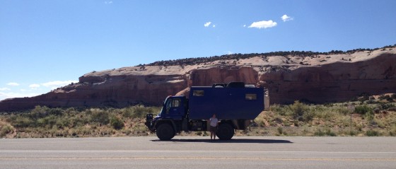
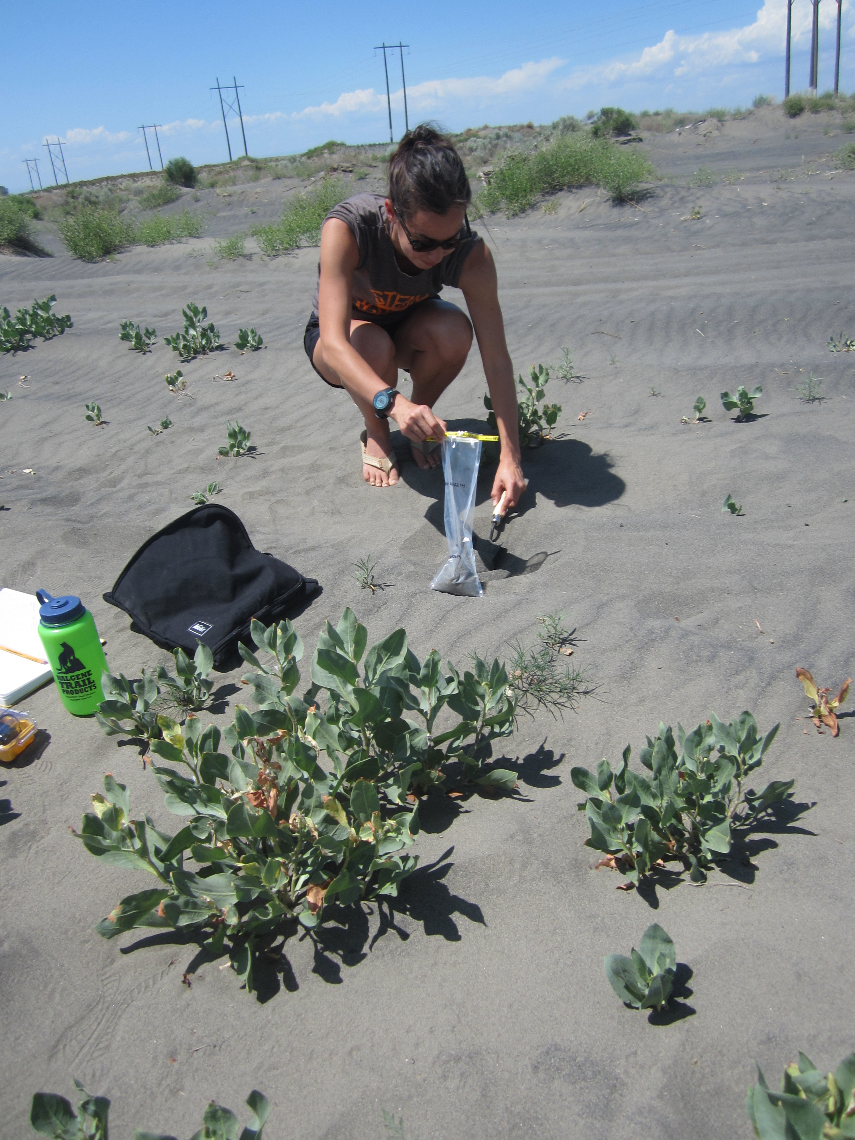
We couldn’t have said it better than a local cowboy who stopped to give us his scientific opinion while we collected material from the cattle-spotted ranchland of northeastern Utah’s Green River Basin—“Well, I’ll tell ya, when it’s dusty, it’s dusty.” Way to hit the nail on the head, huh? Sure enough, we’ve spent the last three weeks shaking dust from our shoes, wiping it out of our eyes, blowing it from our noses. We’ve navigated many of the most arid places in the country, starting off just above sea level, eventually reaching elevations as great as 10,000 feet. Hard to believe we’re all done—for now, at least!

IMG_3526
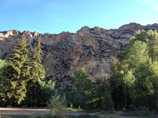
Along this dusty road, we’ve encountered a truly astonishing number of landscapes; each and every evening we pitched our tents, we did so in a totally different setting than the one in which we’d made breakfast. For instance, after we sampled the Green River Basin, we set up camp in Ashley National Forest near the Sheep Creek Geological Area, a place surrounded by enormous, rocky, red and yellow cliffs, thick with quaking aspen, ponderosa, juniper, and lodgepole pines. We watched pronghorns skip across distant ridges, and that night, made sure to watch out for bears, too.

IMG_3529


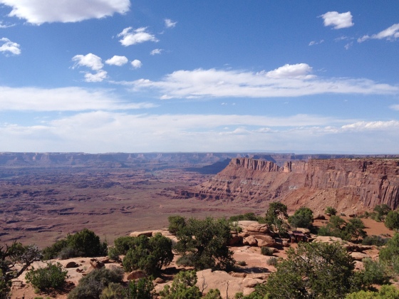
Bright and early the next morning, we set out towards Moab. The drive from northern to southern Utah was full of beautiful, winding roads and spectacular colors, although Sarah and I weren’t really keen on the heat! Still, we were excited about visiting Arches and Canyonlands, as well as the fact that despite the long drive, we were able to cover three sample sites, and manage to snag the last camping spot in the whole park. A successful day indeed!

The formations of Canyonlands and Arches speak to the powerful force of wind in the evolution of landscapes. The salmon-colored Entrada sandstone, where most of the arches occur, was deposited around 200 million years ago. Over time, water and ice infiltrated the surface cracks of  the sandstone layers, breaking off bits and pieces of rock. The holes formed from the cracking continued to be attacked by wind and water, forming arches. While many of these arches gave out long ago, the loose particles left behind carried away by the wind, the most resistant sandstone became the famous arches we see today.

IMG_3547


We drove through thunderstorms, sunshine, across deserts and mountains, past rivers, lakes, and hot springs. Colors, plants, animals and temperatures—they all varied. These are just two of the amazing places we saw during our collection campaign.

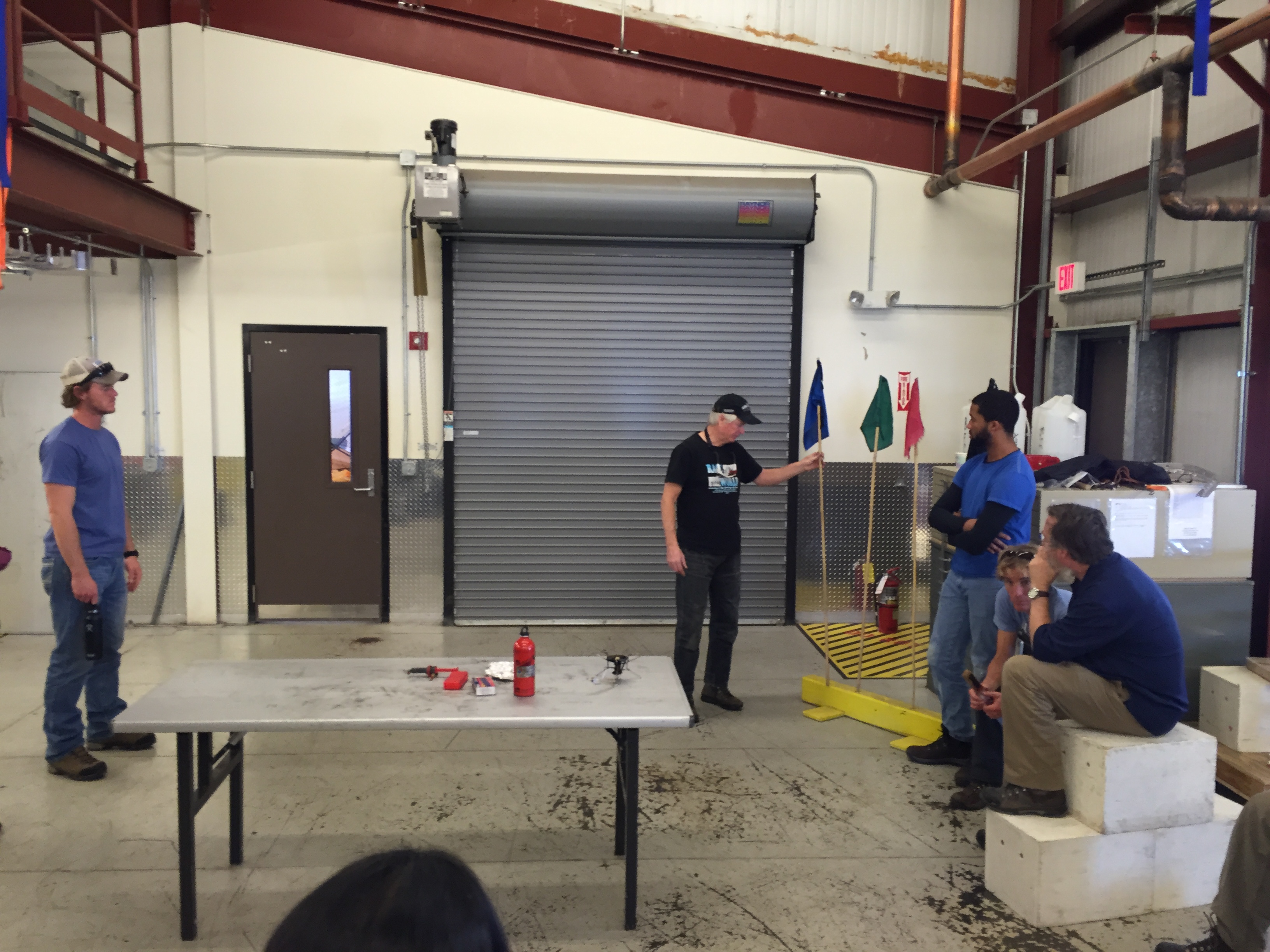
Although we have collected our final sample and the Unimog is headed back up to Alaska, there are still many observations, photos, and stories left to share. Plus, our great American dust quest will resume later on in July when we travel by horse to the Upper Fremont glacier in Wyoming’s Wind River Range. Until then, keep on our your toes for my next update, with photos from our drive across tornado territory and a crazy Colorado dust storm.

Getting the Dirt

Sarah, Charlie, and Molly here, reporting from Gunnison, CO. It’s our eighth day into GIGL’s dust collection quest in the great American West (add on six days on the road for S & C—they drove down to the Lower 48 from Anchorage to meet me in Spokane, WA), and already we’re gearing up to hit the tenth of our thirty proposed sample collection sites.

First thing’s first: you may be wondering why on earth a team of cold weather-loving folks like us has decided to devote an entire month to driving around the desert in the hot summer sun—and stranger yet, why we’ve got big, metal boxes packed with dirt and sand. Don’t worry, we’re already quite used to folks asking questions—just take a look at our ride:

IMG_3463


The goal of our trip is easy enough to explain: we’ve set out to identify the major dust source areas of the western United States. Oftentimes we think of dust as the stuff that collects on our bookshelves and countertops when we get behind in our household chores, but in more arid parts of the country, say Oklahoma or southern California, you can see tiny bits of dust and sand all over the place—sweeping through fields along the freeway, collecting in piles in grocery store parking lots, or even blowing across your own backyard.

IMG_3484

We all know that dust is small—sometimes so small you need a microscope to see it—so it may be hard at first to believe that dust plays such a big role in regional and global climate change. But just think: increased temperatures result in drier land conditions (think of how muddy your front yard can get in the rainy springtime, and how dry it becomes later on in the summer). With less moisture to hold soil particles together, the ground material becomes less consolidated and easier to blow away in the wind. The wind is a powerful mode of transport, and can carry tiny bits of sand and clay vast distances—even across continents—but no matter where the dust ends up, there remain a variety of important consequences. For starters, when windblown dust settles on land, it can supply nutrients to the local soil and plant life, and the same goes for dust settling in the ocean, or carried by rivers out to the ocean. Dust also darkens snow and ice surfaces, thereby decreasing Earth’s albedo, or it’s ability to reflect solar radiation.

IMG_2759Many studies have pointed towards increased dustiness on snow cover in the western US over the past two centuries, most likely due to land-use changes like agricultural practices and livestock grazing…but where exactly is all of that dust coming from? And why? Are the most prominent dust sources in areas where humans have made major changes to the landscape? At the end of the summer, we’ll haul our treasure chest full of dirt back to our lab at the University of Michigan and begin our geochemical analyses so that we may answer these important questions. In the meantime, we hope you’ll check back with us as we continue “getting the dirt” on arid regions throughout the American northwest, southwest, and Colorado Plateau. We’re excited to talk a bit more about what we’ve collected so far, and show you some of the incredible landscapes we’ve encountered. Until we next run into some WiFi, this is the GIGL dust team from our big, blue UNIMOG, going clear!

IMG_2765

Work hard, play hard

The last day of work for me in Tromso this time was to put all the shells back into their individual home, and did the final check of the pH levels.

DSCF8588 DSCF8597

DSCF8599

Here you can see the calcein were released from the shell after we put them back!

DSCF8603DSCF8602


As all the pH levels were stable, we were ready to go for the next half of experiment.

Aside from the work, I also experienced the beauty of the the northern Norway. In February, I was really lucky to see the northern light on one night before I left.

DSCF8405 DSCF8406


Also, working on the coast means you might have some luck for fresh seafood! Thanks people there let me taste the “real halibut”! That’s yum!!!

DSCF8529 DSCF8573


Of course, the most important event in May here is Norway’s national day on the 17th. I was pretty lucky to anticipate this big celebration in both last and this year, enjoying the crowds and atmosphere, especially seeing the parades downtown.

DSCF8619 DSCF8637 DSCF8709 DSCF8710 DSCF8718 DSCF8720 DSCF8722 DSCF8728 DSCF8731 DSCF8732 DSCF8740


Work hard, play hard. To have chances going different places when doing fieldwork is one of the most important reason why I like geology!

DSCF8652